Rick
Harper
Ashley
Dockins
Where
is the Grand Canyon, how was it formed, and what types of Rock Layers
are
there?
Cognitive
Goal: The
student will know
where Grand Canyon National Park is and the rock walls are different
ages as
well as different rocks.
Affective
Goal: The
student will
appreciate that the Grand Canyon was formed by the Colorado River over
about
six million years and that this is an awesome display of the powers of
nature.
Standards:
Illinois:
17.A.2a
Compare the physical characteristics of places including soils,
land
forms, vegetation, wildlife, climate, natural hazards.
17.A.2b Use
maps and other geographic representations and instruments to gather
information
about people, places and environments.
National:
3.f Social
studies programs should include experiences that provide for the study
of
people, places, and environments, so that the learner can describe and
speculate about physical system changes, such as, seasons, climate and
weather,
and the water cycle.
Lesson
Objective: The
student will know
where the Grand Canyon is when presented with a map and the student
will fill
out a diagram indicating the different rock layers that are viewed on
the
canyon walls.
Materials: Map
from week one,
worksheets, pictures of Grand Canyon
Resources: Retrieved
October 18,
2009, from http://www.frommers.com/destinations/grandcanyonnationalpark/2284026075.html#ixzz0UPh4GfF0
Retrieved
October 18, 2009, from http://www.naturescience.org/nathist/layers_pages/layers_cover/layers.html
Retrieved
October 18, 2009, from http://www.bobspixels.com/kaibab.org/misc/gc_coriv.htm
Retrieved October 18, 2009, from http://www.cst.cmich.edu/users/kiefe1we/HorizontalTiltedFoldedAns.htm
Markert,
Jenny. (1992). The Grand Canyon. Chicago, IL: Encyclopedia
Britannica
Focusing
Activity: Good
morning. Today we are going to learn about
a different
one of our National Parks. We are going
to start learning about the Grand Canyon.
Does anyone know something about the Grand Canyon before we
begin? The students may respond that it is
very
tall; they may say it is in Arizona, or they might tell us that it is
very
old. All of these answers are correct
and we are going to discuss where the Grand Canyon is on the map, how
the walls
of the canyon were made, and what types of rocks make the walls.
Instructional
Input: The
teacher will start
by asking the students to take out their maps they have made from week
one. The teacher will ask the students
where Arizona is on their maps. The
teacher will ask the students to point to the Northwest area of Arizona. The students should respond by pointing
to the upper left corner of Arizona. The
teacher will then tell the students that the Grand Canyon is on the
Colorado
River and that it was made by erosion.
The students will label their maps with a new color to depict
where this
national park is located.
The
students will probably ask what erosion is at
this point. The teacher will explain
that erosion is the process of wearing away areas of land.
The teacher will ask the students if they
have ever spilled water on the dirt and saw the water move on the
ground. The students may say yes or no. If they say yes, or no, then the teacher will
explain that when the water is moving on the dirt it is pushing some of
the
dirt out of the way of the water. As
water moves the dirt and ground away there is an impression of where
the water
flowed. This is the process known as
erosion. The teacher will also explain
that it gets cold during the winter at the Grand Canyon.
During the winter ice forms in the cracks of
the rocks and chips away at parts of the canyon walls.
The teacher will then demonstrate erosion
using a plate of dirt and pouring water on to it to show how water
wears away
and moves the dirt out of the way of the water.
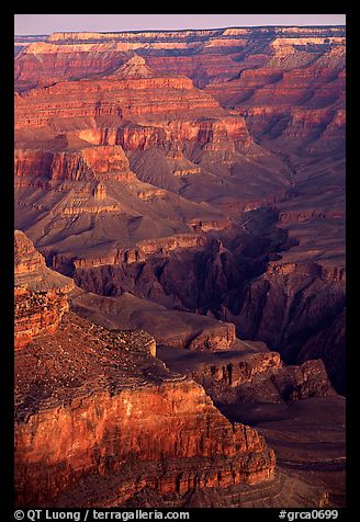
The
teacher will then discuss how the rocks are
older at the bottom of the canyon at the river.
The teacher will then talk about the younger rocks being on top
of the
older rock formations. At this point the
teacher will ask students why the older rocks would be on the bottom. The student will respond that new things were
added to the top. The teacher will then
talk about the ten visible layers of rock that can be seen on the
canyon
sides.
The
bottom layer is called the Vishnu Schist. It
is about 1.7 billion years old. It is
black in color and is where the
Colorado River is now located. The next
oldest layer is called Tapeats Sandstone and it is around 545 million
years
old. This layer of rock is mostly sand
that has been pressed into sandstone.
The next oldest layer is called Bright Angel Shale and it is
about 540
million years old. This layer of the
Grand Canyon looks blue-gray in color.
Which way does the age of the rocks go?
Do the rock layers get older or younger as they go up? The students should respond that they get
younger as the rocks go up from the bottom.
The
layer on top of the Bright Angel Shale is called
Muav Limestone and this layer is about 530 million years old. This layer is made of limestone and is
yellowish in color. The next layer is
called the Redwall Limestone and it is 800feet high in some areas. This layer is about 330 million years old and
has been stained a rust color on top of its natural silver-gray. The middle layer is known as the Supai Group
and it is about 300 million years old.
This layer is red in color and forms ledges above the Redwall
Limestone
layer. How would the Redwall Limestone
layer look in color if the Supai Group layer did not stain it? The students should respond that it would
look silver-gray.
Hermit
Shale is the next layer up and it is an even
darker red than the Supai Group layer.
This layer is about 285 million years old. The
next layer up is known as Coconino Sandstone
layer and it is the third layer form the top.
This layer is around 270 million years ago and it is the color
of a dark
sand.
The
second layer is called the Toroweap Formation
and it is around 260 million years old.
This layer looks yellow-gray. The
top layer is called the Kaibab Limestone layer.
This layer is around 250 million years old.
There were layers that were younger on top of
this layer but they were eroded away.
Who remembers what erosion is? The
students should respond when water moves the ground out of its way.
Response
Activity: The
students will fill out
a worksheet of the different rock layers.
On the worksheet the students will list how old the rock layers
are. The students will also update their
maps of the four corners area from the previous weeks.
The students will also color their construction
paper the color(s) of each layer
in order of the oldest rocks on the bottom and the youngest rocks on
the top.
Conclusion: Today
we learned where
Grand Canyon National Park is located.
Which state is this national park located? Arizona.
Which part of the state is the Grand Canyon at?
It is in the Northwest. We also
learned that the rock layers get
younger as they go to the top. How old
is the bottom layer? It is 1,700,000,000
years old. Next, week we are going to
study about some of the plants and animals that live in or around the
Grand
Canyon.