IL Hydro
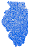
USGS Hydrography data for the state of Illinois, filtered and generalized so that you can easily find the streams that you need for your next mapping project.
Data Downloads
Highlights
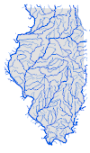
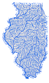
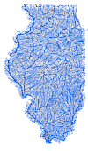
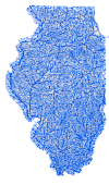
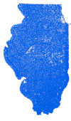
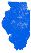
- Choose from 7 different levels of resolution.
- Easily filter streams further using Select by Attributes on:
- Main Stem Rank
- Main Stem Flow Volume
- Main Stem Name
- Lookup field and accompanying table link back to original USGS National Hydrography Dataset (NHD) identifiers.
About the Illinois Hydro Project
Our team has worked to create a multi-scale repository of stream data for the state of Illinois. This project combines stream data from across 13 USGS HU-4 subregions and uses simplification techniques, such as filtration and the use of simplification algorithms, to enable all users to have access to stream data for the state of Illinois. We currently provide seven different levels of filtration, which enable the user to further filter the data in multiple possible ways. For more information regarding how we have created these feature layers, information regarding attribute fields, or clarification of terms used in this project, please view the user guide.
Future Work (in progress)
- feature generalization appropriate to target scales
- quality assessment metrics with information on feature accuracy, legibility
Contributors
- Cameron Clark (PSM graduate, 2025)
Contact
Barry Kronenfeld, bjkronenfeld@eiu.edu